
Who knew that beneath Brooklyn’s urban jungle lies a hidden oasis? Rivers in Brooklyn, once the lifeblood of bustling industries, now offer serene escapes and a treasure trove of history. With 26 miles of winding waterways, these liquid gems add a splash of charm to the borough.
Dive in as we uncover their secrets, share fascinating anecdotes, and reveal the must-visit spots that’ll make you fall in love with Brooklyn’s aquatic allure!
Key Takeaways
- Brooklyn’s rivers shaped its history, development, and identity, fostering economic growth and providing vital resources.
- Restoration efforts are crucial to address pollution, protect wildlife, and ensure the ongoing vitality of Brooklyn’s waterways.
- Green infrastructure investments, like bioswales, can help manage stormwater sustainably and create healthier urban environments.
Importance of rivers in Brooklyn
Brooklyn’s rivers and waterways have long played a critical role in shaping the borough’s unique urban identity. These waterways have fostered economic growth, facilitated transportation, and provided vital recreational and environmental resources for the community.
The Role of Rivers in Brooklyn’s History and Development
The rivers have been instrumental in Brooklyn’s development, from its early days as a Dutch settlement to the thriving, diverse urban area it is today. The waterways have served as a hub for industry and transportation, and they continue to play a key role in the borough’s ongoing revitalization.

Overview of Brooklyn’s Rivers
Brooklyn is home to several significant rivers and waterways, each with its own unique history and characteristics. These include:
- The East River
- The Gowanus Canal
- Newtown Creek
- Coney Island Creek
- Jamaica Bay
| River Name | Type of Waterway | Length | Location | Notable Features |
|---|---|---|---|---|
| East River | Tidal Strait | 16 miles | Between Upper New York Bay and Long Island Sound | Iconic bridges, Newtown Creek, Roosevelt Island |
| Gowanus Canal | Artificial Canal | 1.8 miles | Gowanus neighborhood, connecting to Upper New York Bay | Urban-industrial landscape, ongoing revitalization effort |
| Newtown Creek | Estuary | 3.5 miles | Separates Brooklyn and Queens | Four tributaries (Dutch Kills, Whale Creek, Maspeth Creek, English Kills) |
| Coney Island Creek | Tidal Inlet | 1.8 miles | Separates Coney Island from the mainland | Parks, trails, and waterfront vistas |
| Jamaica Bay | Estuary | 25,000 acres | Brooklyn’s southeastern shoreline | Wetlands, islands, and open water; diverse wildlife |
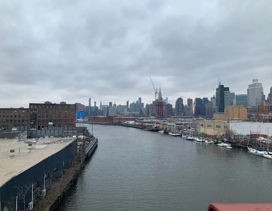
The East River
Geographical features
The East River, often mistaken as a river, is actually a tidal strait stretching 16 miles between the Upper New York Bay and the Long Island Sound. This impressive waterway flows alongside Brooklyn, separating it from Manhattan and the Bronx. Its varying width, ranging from 600 to 4,000 feet, creates a stunning visual contrast.
The East River is punctuated by noteworthy features like Roosevelt Island, several iconic bridges, and the famous Newtown Creek, contributing to its unique character and rich maritime history.
History and significance
The East River has been a critical transportation and commercial artery since the 17th century, with its shores providing prime locations for industry and commerce.
Development and gentrification
Over the past few decades, the East River waterfront has experienced significant development and gentrification, with new residential and commercial projects transforming the area.
Parks and recreational activities
- Brooklyn Bridge Park
Brooklyn Bridge Park, a vibrant 85-acre park along the East River, offers a range of recreational activities and stunning views of the Manhattan skyline.
- Domino Park
Domino Park, a 6-acre public park in Williamsburg, was built on the site of the former Domino Sugar Refinery and features an elevated walkway, playgrounds, and more.
- WNYC Transmitter Park
WNYC Transmitter Park, a 6.6-acre green space in Greenpoint, was once the site of a radio transmission facility and now offers a waterfront esplanade, playground, and public art installations.
The Gowanus Canal
Geographical features
The Gowanus Canal, a 1.8-mile-long artificial waterway in Brooklyn, was initially created as a means to support industrial development in the 19th century. Meandering through the Gowanus neighborhood, the canal connects to Upper New York Bay via Gowanus Bay.
Once lined with factories and warehouses, the area surrounding the canal has undergone a significant transformation. Today, the Gowanus Canal’s distinct urban-industrial landscape is juxtaposed with new residential and commercial developments, parks, and an ongoing revitalization effort.

History and industrial past
The Gowanus Canal, built in the 19th century, was once a thriving industrial waterway. It played a significant role in the growth of Brooklyn’s manufacturing sector.
Environmental challenges
Over the years, the canal has become severely polluted, posing significant environmental and health risks.
Gowanus Canal Conservancy
The Gowanus Canal Conservancy is a non-profit organization dedicated to the restoration and revitalization of the canal and its surrounding neighborhoods.
Future development plans
Efforts are underway to clean up the canal and transform it into a vibrant waterfront destination with parks, housing, and commercial spaces.
Newtown Creek
Geographical features and surrounding neighborhoods
Newtown Creek, a 3.5-mile-long estuary, forms part of the border between Brooklyn and Queens. This historic waterway, once an industrial hub, flows into the East River and is home to four tributaries: Dutch Kills, Whale Creek, Maspeth Creek, and English Kills. Though marred by past pollution, ongoing restoration efforts aim to revive its ecological vitality.
Newtown Creek’s unique blend of industrial heritage and natural beauty coexists with modern urban development, creating a fascinating, ever-evolving landscape.
Industrial history
Like the Gowanus Canal, Newtown Creek was once a bustling industrial waterway, but its heavy use led to severe pollution.
Environmental issues and restoration efforts
Efforts by local organizations and government agencies are underway to address pollution and restore the creek’s ecosystem.
Recreational opportunities
Newtown Creek offers limited recreational activities, including kayaking and bird-watching. However, more opportunities are expected to emerge as restoration efforts progress.
Coney Island Creek
Geographical features
Coney Island Creek, a 1.8-mile-long tidal inlet, is situated along Brooklyn’s southern coast. Once a vast marshland, this waterway played a significant role in Coney Island’s development. The creek, which separates the main island from the mainland, is fed by Sheepshead Bay and Gravesend Bay.
Despite its industrial past, Coney Island Creek now boasts a unique blend of natural beauty and recreational opportunities, with parks, trails, and waterfront vistas offering picturesque views and a tranquil urban oasis.
History and transformation
Coney Island Creek, once a thriving waterway with shipbuilding and other industries, has undergone significant transformations over the years.
Wildlife and natural habitat
Despite past environmental challenges, the creek now supports a diverse array of wildlife, including various bird species and marine life.
Recreational activities and public access
Coney Island Creek offers numerous recreational opportunities, such as kayaking, bird-watching, and fishing.
Coney Island Creek Park
Coney Island Creek Park is a waterfront green space featuring walking paths, playgrounds, and stunning views of the creek and surrounding area.
Jamaica Bay
Geography and significance
Jamaica Bay, an expansive 25,000-acre estuary, graces Brooklyn’s southeastern shoreline, encompassing wetlands, islands, and open water. This ecological gem is part of the Gateway National Recreation Area and plays a vital role in supporting diverse wildlife, including hundreds of bird species.
With a multitude of bays and inlets, Jamaica Bay’s vast network of waterways offers an idyllic retreat for nature enthusiasts, birdwatchers, and kayakers. It’s serene beauty and rich biodiversity provides a captivating contrast to Brooklyn’s bustling urban landscape.
Wildlife and natural habitats
Jamaica Bay is home to a wide variety of wildlife, including over 300 bird species, making it an essential stopover for migratory birds.
Gateway National Recreation Area
The Gateway National Recreation Area, which includes Jamaica Bay, offers a range of recreational activities, such as hiking, bird-watching, and camping.
Jamaica Bay Wildlife Refuge
The Jamaica Bay Wildlife Refuge, part of the Gateway National Recreation Area, is a sanctuary for a diverse array of flora and fauna, offering numerous trails and educational programs for visitors.
Bridges over Brooklyn’s Rivers
Several iconic bridges span Brooklyn’s rivers, connecting the borough to Manhattan and Queens. These architectural marvels include the Brooklyn Bridge, the Manhattan Bridge, the Williamsburg Bridge, and the Kosciuszko Bridge.

The Future of Brooklyn’s Rivers
Environmental Concerns and climate change
As climate change poses new challenges for Brooklyn’s rivers, ongoing efforts to address pollution and protect natural habitats are vital for preserving these vital resources.
Ongoing restoration efforts
Restoration efforts for Brooklyn’s rivers and waterways will continue, with the goal of improving water quality, protecting wildlife, and expanding recreational opportunities.
Public access and recreational opportunities
Improved public access and recreational opportunities will remain a priority, ensuring that Brooklyn’s rivers and waterways can be enjoyed by all.
Discovering Brooklyn’s Buried Rivers
From atop Litchfield Villa in Brooklyn’s Prospect Park, remnants of hidden rivers can be traced to Gowanus Bay. Once nourished by over a dozen streams (see the difference between rivers and streams), the area’s waterways have been buried or confined to pipes for 150 years.
The Impact of Urbanization on Waterways
As cities expand and the climate warms, drainage crises worsen. Urban flooding disrupts sewage systems, overwhelms treatment plants, and contaminates drinking water. In Brooklyn, the hidden rivers contribute to basement flooding and sewer overflows.
Green Infrastructure for a Sustainable Solution
New York City is investing in green infrastructure like bioswales, which help reduce combined sewer overflows. Other cities are following suit, adopting similar strategies to manage stormwater more sustainably. Green infrastructure can improve property values, mitigate local flooding, and provide havens for plants and animals.
Reviving Gowanus Canal and its Hidden Streams
Diegel, an urban planner, dreams of daylighting streams in the Gowanus area, restoring the natural flow of water, and revitalizing the canal. By embracing nature’s resilience and innovation, cities can address stormwater management challenges and create a greener, healthier urban environment.
Conclusion
In summary, Brooklyn’s rivers and waterways are an essential part of the borough’s history, development, and identity. These hidden gems have played a vital role in fostering economic growth, providing transportation, and offering recreational and environmental resources for the community. From the East River to Jamaica Bay, each of these waterways has a unique story and character that adds to the charm of Brooklyn.
As restoration efforts continue to address pollution, protect wildlife, and enhance the vitality of these aquatic treasures, it is crucial for us to acknowledge and appreciate their importance. By understanding and preserving these waterways, we can ensure that future generations can enjoy the serene escapes, natural beauty, and rich history that Brooklyn’s rivers have to offer.
FAQs
Are the rivers in Brooklyn safe for swimming?
While water quality has improved in recent years, swimming in Brooklyn’s rivers is generally not recommended due to ongoing pollution concerns.
Can you fish in Brooklyn’s rivers?
Fishing is allowed in certain areas, but consumption of the catch is not advised due to potential contaminants.
What is being done to improve water quality?
Efforts by government agencies, non-profit organizations, and community groups are ongoing to address pollution and restore water quality in Brooklyn’s rivers.
How can I get involved in river restoration efforts?
There are numerous organizations dedicated to river restoration in Brooklyn. Volunteering, donating, or participating in local events can help support these