
From Rivers to Skylines: Unraveling Urbanization’s Secret is a captivating journey into the hidden forces that shape our cities. Did you know that rivers hold the key to unlocking urban growth?
In this article, we delve into the intriguing connection between rivers and the soaring skylines that define modern urban landscapes. Discover how these majestic waterways, often overlooked, wield immense influence over economic development, architectural design, and the sustainable future of our cities.
Brace yourself for a captivating exploration that will forever change your perception of urbanization’s secret. Read on to unravel the untold story behind rivers and skylines.
Historical Perspectives
Ancient Civilizations and Rivers: Egypt, Mesopotamia, Indus Valley, and China
Ancient civilizations thrived along the world’s great rivers, harnessing their waters for survival and development. Egypt was built around the life-giving Nile, using its annual floods to cultivate the arid lands. Mesopotamia, the land between the Tigris and Euphrates, saw the rise of early city-states, using irrigation from these rivers to pioneer agriculture. The Harappan civilization of the Indus Valley and the early dynasties of China along the Yellow River similarly used their rivers for farming, trade, and transportation.
Rivers as Trade and Transportation Routes in Middle Ages
In the Middle Ages, rivers were the highways of the era. They provided reliable and economical routes for the transportation of goods, enabling trade between towns, regions, and countries. Rivers like the Danube and the Rhine became pivotal arteries of commerce and communication, leading to the growth of prosperous medieval cities along their banks.
Industrial Revolution: The Shift from Agrarian Societies to Urban Centers
The Industrial Revolution saw a shift from agrarian societies to urban centers. Rivers played a central role in this transformation. They were harnessed for mechanized power to fuel mills and factories. Cities grew around these industrial hubs, attracting workers and leading to unprecedented urbanization. The River Thames in England and the Merrimack in the U.S. are among many that powered this industrial and urban shift.
Biggest Urban Rivers in the US
| River | City | Length (miles) | Flow (cubic feet per second) |
|---|---|---|---|
| Mississippi River | Minneapolis-St. Paul, MN | 2,320 | 593,000 |
| Missouri River | Kansas City, MO | 2,341 | 56,500 |
| Ohio River | Louisville, KY | 981 | 281,500 |
| Rio Grande | El Paso, TX | 1,896 | 1,783 |
| Colorado River | Las Vegas, NV | 1,450 | 9,000 |
| Willamette River | Portland, OR | 187 | 61,000 |
| Potomac River | Washington, D.C. | 405 | 11,000 |
| Hudson River | New York City, NY | 315 | 21,200 |
| Tennessee River | Chattanooga, TN | 652 | 62,100 |
| Charles River | Boston, MA | 80 | 5,700 |
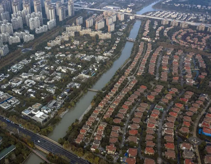
Rivers and Urban Planning
The Strategic Role of Rivers in City Placement and Growth
Rivers have played a strategic role in the placement and growth of cities throughout history (incl. river crossings, see our article). Early settlements were often situated near rivers for their resources like fresh water, food, and transportation. As settlements grew into cities, rivers continued to provide strategic advantages. They facilitated trade, enabling goods to be transported cheaply and efficiently, and fostering economic growth.
Rivers also served as natural boundaries, influencing the expansion and defensive strategies of urban areas. Today, many of the world’s largest cities, from London to New York, owe their location and economic prosperity to nearby rivers.
Influence of Rivers on Urban Design and Architecture
Rivers have also significantly influenced urban design and architecture. City layouts were often dictated by the course of the river, leading to unique street patterns that followed the river’s flow. Waterfront areas became focal points of urban life, with markets, docks, and public spaces lining the river’s edge.
In terms of architecture, rivers have inspired a plethora of structures from bridges to riverfront promenades, often becoming iconic symbols of their cities. For instance, the River Seine has shaped the urban fabric of Paris, while the Thames has been instrumental in defining the architectural character of London.
Urban Architecture influenced by rivers in the example of London, UK
One key example of this influence is the construction of the various bridges spanning the river. These structures not only serve practical purposes but also contribute significantly to the city’s architectural aesthetic.
The Tower Bridge, a symbol of London itself, is a prime example. Completed in 1894, its unique design combined elements of both a suspension and a drawbridge, featuring two neo-Gothic towers connected by high-level walkways. This architectural marvel was a response to the need to allow ships to pass while also providing a means for pedestrians and vehicles to cross the river.
Along the riverbanks, the Thames has spurred the development of numerous significant buildings and institutions. The Houses of Parliament and the London Eye, both situated on the Thames, are notable examples. The former, an iconic example of Gothic Revival architecture, was deliberately built along the river for both strategic and aesthetic reasons. The latter, a modern architectural wonder, takes full advantage of its river location for its panoramic views of the city.
In this way, the River Thames has shaped London’s architecture, contributing to a cityscape that blends historical structures with modern design, all centered around the meandering path of the river.

Rivers as Economic Catalysts in Urbanization
Rivers have been integral to economic development and urbanization, acting as catalysts for industry, trade, and tourism. They have powered innovation, driven commerce, and created leisure opportunities that have shaped our cities and their economies.
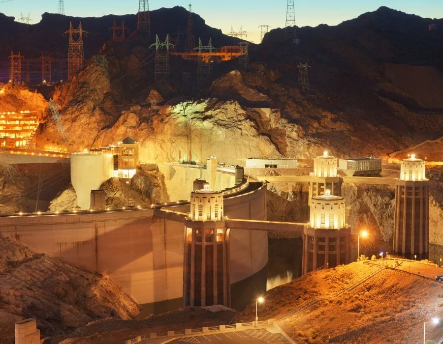
Rivers as Power Sources: Driving Industry and Innovation
Since the dawn of the Industrial Revolution, rivers have been harnessed as sources of power. Factories were built along riverbanks, using water wheels to generate mechanical energy. For instance, the River Clyde in Scotland was instrumental in the growth of the shipbuilding industry in Glasgow.
Even today, rivers continue to drive industry through hydroelectric power generation. The Hoover Dam on the Colorado River, for example, provides power to millions of people across several states in the U.S.
Rivers and Trade: The Lifeblood of Urban Economies
Rivers have long served as critical routes for trade and transportation, accelerating economic growth in urban areas. The Rhine River in Europe, for instance, is one of the busiest waterways in the world, facilitating the movement of goods between numerous countries and cities, fueling economic activity and urbanization.
Similarly, the Mississippi River has been a major artery for trade in the United States, serving as a conduit for agricultural and industrial products.
Tourism and Recreation: Capitalizing on Riverfront Attractions
Urban rivers also contribute significantly to tourism and recreation, often becoming focal points for these activities. The Seine River in Paris, with its river cruises, iconic landmarks, and picturesque quays, attracts millions of tourists each year, contributing enormously to the city’s economy.
The San Antonio River Walk in Texas, a vibrant urban waterfront with restaurants, shops, and cultural attractions, draws a large number of visitors, stimulating the local economy and enhancing urban life.
Table: Top 10 biggest urban rivers in the world
| River | City | Length (miles) | Flow (cubic feet per second) |
|---|---|---|---|
| Yangtze River | Shanghai, China | 3,917 | 980,000 |
| Ganges River | Kolkata, India | 1,569 | 42,000 |
| Amazon River | Manaus, Brazil | 4,345 | 6,330,000 |
| Nile River | Cairo, Egypt | 4,135 | 85,700 |
| Mississippi River | New Orleans, United States | 2,320 | 593,000 |
| Huangpu River | Shanghai, China | 71 | 49,800 |
| Thames River | London, United Kingdom | 215 | 14,700 |
| Seine River | Paris, France | 482 | 2,570 |
| Danube River | Budapest, Hungary | 1,771 | 300,000 |
| Rhine River | Cologne, Germany | 766 | 68,000 |
Ecological Perspectives
Rivers are not just conduits for water; they are dynamic ecological systems that provide crucial services to urban environments. They are instrumental in water purification, flood control, and providing habitats for urban wildlife. Moreover, they play an integral role in climate regulation and mitigating urban heat islands.
Ecosystem Services: Water Purification, Flood Control, and Wildlife Habitats
Rivers are natural water purifiers. As water flows, sediments and pollutants are filtered out, improving water quality. For example, the Charles River in Boston has seen significant water quality improvements due to natural processes and dedicated cleanup efforts. Rivers also play a critical role in flood control. River floodplains can absorb excess rainwater, reducing flood risks in urban areas.

For instance, the floodplains of the River Thames have been instrumental in protecting London from flooding. Furthermore, rivers provide habitats for a diverse range of wildlife. In urban settings, rivers can serve as critical green corridors for birds, fish, and mammals.
Urban Climate Regulation: Rivers as Natural Coolants
Rivers can help regulate urban climates by acting as natural coolants. The water in rivers absorbs and dissipates heat, thereby reducing the surrounding air temperature.
For example, the Danube River helps moderate temperatures in cities like Vienna and Budapest, making them more comfortable in the summer months.
Urban Heat Island Mitigation: The Role of Rivers
Rivers also contribute to mitigating the urban heat island effect, a phenomenon where urban areas are significantly warmer than their rural surroundings due to human activities. By providing moisture and cooling the surrounding air, rivers can help lower the overall temperature of urban areas.
The Yarra River in Melbourne, Australia, is a good example of this, playing a significant role in mitigating the city’s heat island effect.

Challenges and Conflicts
Urbanization brings with it a set of challenges and conflicts related to rivers, which are crucial resources for cities. Three significant challenges include water pollution, flooding, and water scarcity, all of which have profound implications for urban planning and river management.
Water Pollution: Impact on River Health and Urbanization
The rapid growth of cities and increased human activity have led to water pollution, posing a threat to river health and the well-being of urban environments. Industrial waste, agricultural runoff, and untreated sewage are among the main contributors to water pollution.
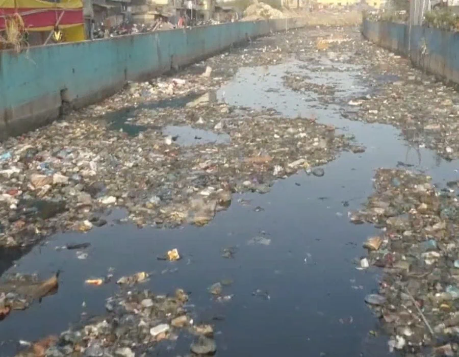
These pollutants not only degrade water quality but also harm aquatic ecosystems and the biodiversity they support. Addressing water pollution is vital for safeguarding both the health of rivers and the sustainability of urbanization.
Mithi River The Pollution Of Poverty | We Are Water Foundation
Flooding: Challenges for Urban Planning and River Management
Flooding presents a major challenge for urban planning and river management. As cities expand and impervious surfaces increase, the capacity of rivers to handle excess water diminishes. When heavy rainfall or storms occur, urban areas with inadequate drainage systems are prone to flooding, leading to property damage, displacement of residents, and even loss of life.
Effective urban planning strategies, such as green infrastructure and improved stormwater management, are crucial to mitigate the risks associated with flooding and protect cities from its devastating effects.
Water Scarcity: Implications for River Management in Urban Areas
Water scarcity further complicates river management in urban areas. As populations grow and water demands increase, rivers often face overuse and depletion. Climate change exacerbates water scarcity by altering precipitation patterns and reducing water availability.
Urban areas must implement sustainable water management practices, such as water conservation measures, efficient irrigation systems, and water reuse strategies, to ensure the long-term viability of both rivers and the urban communities that depend on them.
Innovative Approaches and Future Directions
Many cities are adopting innovative approaches to river management, such as green infrastructure and urban river restoration. The integration of rivers into sustainable urban development is seen as a key strategy for future urban planning.
Green Infrastructure: Enhancing River Management and Urban Resilience
Green infrastructure refers to the incorporation of natural elements, such as vegetation and permeable surfaces, into urban planning to manage stormwater, enhance water quality, and promote environmental sustainability. This approach not only improves river management but also enhances the resilience of urban areas to climate change impacts.
One practical example of green infrastructure implementation is the Cheonggyecheon Stream Restoration Project in Seoul, South Korea. The project involved removing an elevated highway and restoring the stream, creating a linear park with green spaces and pedestrian pathways. The revitalized stream improved water quality reduced the urban heat island effect, and provided recreational opportunities for residents.
Urban River Restoration: Reclaiming the Natural Beauty of Rivers
Urban river restoration focuses on revitalizing degraded rivers by restoring their natural features and ecosystems. It involves removing barriers, improving water quality, and creating habitats for wildlife.
A notable example of urban river restoration is the Los Angeles River Revitalization Project in California, United States. This ambitious project aims to transform a concrete-lined channel into a restored and vibrant river corridor with increased access to green spaces, improved water quality, and enhanced ecological habitats. By reconnecting communities with the natural beauty of the river, this restoration effort seeks to improve the overall livability and ecological health of the city. Explore the Los Angeles River Revitalization Project

Integrating Rivers into Sustainable Urban Development: A Vision for the Future
Integrating rivers into sustainable urban development involves considering rivers as integral components of urban planning, with a focus on balancing social, economic, and environmental needs.
One visionary example is the Bishan-Ang Mo Kio Park in Singapore. This park incorporates the natural meandering Kallang River, creating a harmonious blend of recreational spaces, natural habitats, and water management features. The park’s design allows for flood mitigation through the integration of bio-retention basins and wetland ecosystems. This innovative approach demonstrates how rivers can be seamlessly integrated into urban environments, providing multiple benefits for residents, wildlife, and the overall sustainability of the city.
Conclusion
Rivers are the lifeblood of urbanization, shaping and supporting our cities in myriad ways. As we move forward, a holistic understanding of their role is essential for sustainable urban development.
Outlook and Future: Embracing Rivers for Sustainable Urban Development
As we look to the future, it is crucial to embrace the role of rivers in sustainable urban development. By prioritizing their preservation, incorporating green infrastructure, and implementing innovative river management practices, we can create resilient cities that thrive in harmony with nature.
Embracing the Role of Rivers: Key Considerations for Sustainable Urbanization
To ensure sustainable urbanization, it is imperative to fully embrace the role of rivers. This involves recognizing their ecological importance, leveraging their economic potential, and integrating them seamlessly into urban planning. If we want, we can create vibrant and resilient cities that balance human needs with environmental stewardship.