
Have you ever marveled at the power and beauty of flowing rivers? Beyond their breathtaking appearance, rivers hold a secret force that profoundly influences our surrounding ecosystems.
From providing essential habitats for aquatic life to shaping the landscapes of riparian zones, river currents play a vital role in the delicate balance of nature. In this article, we will dive into the depths of these enigmatic currents, unraveling their mysteries and exploring their intricate connection to the diverse web of life.
Get ready to discover the fascinating ways in which river currents shape our ecosystems and the urgent need to protect these life-giving waterways. Let’s embark on this enlightening journey together.

Understanding Basic River Current Concepts
River currents are the continuous, directed movements of water generated by different forces. The study of these currents not only reveals the physical properties of rivers but also provides valuable insights into the interconnectedness of nature and human activities.
Different Components of River Currents
River currents are comprised of several components including:
- the speed of the water flow
- the direction of the flow
- the vertical structure, which can be influenced by factors such as riverbed topography, weather, and obstructions.
Importance of River Currents
Understanding river currents is crucial. They play a significant role in shaping the river ecosystem, influencing human activities like navigation and recreational water sports, and even impacting weather patterns.
Table: top 20 rivers with the highest average current speed
| River | Location | Average Current Speed (m/s) |
|---|---|---|
| Amazon River | South America | 2.7 |
| Congo River | Africa | 2.3 |
| Yangtze River | China | 2.0 |
| Mississippi River | United States | 1.6 |
| Indus River | Pakistan | 1.5 |
| Orinoco River | South America | 1.4 |
| Mekong River | Southeast Asia | 1.3 |
| Yukon River | Canada, United States | 1.2 |
| Paraná River | South America | 1.1 |
| Nile River | Africa | 1.0 |
| Ganges River | India, Bangladesh | 0.9 |
| Amur River | Russia, China | 0.8 |
| Tocantins River | Brazil | 0.7 |
| Mackenzie River | Canada | 0.6 |
| Darling River | Australia | 0.5 |
| Kolyma River | Russia | 0.4 |
| Lena River | Russia | 0.3 |
| Rhine River | Europe | 0.2 |
| Danube River | Europe | 0.1 |
| Colorado River | United States, Mexico | 0.1 |
Formation of River Currents
Understanding the formation of river currents involves exploring several key factors.
Role of Gravity
Gravity is the driving force behind river currents. Simply put water, being a fluid, moves from areas of high potential energy (higher ground) to areas of low potential energy (lower ground). This natural inclination is due to gravity. For instance, the rapid descent of water in a waterfall exemplifies this phenomenon, as water is pulled down by gravity, leading to a strong current at the base.
Influence of Topography
Topography, or the physical features of the land, greatly affects the speed and direction of river currents. Rivers often follow the path of least resistance, winding their way around hills and through valleys. A flat terrain leads to slower river currents, while steep slopes generate faster currents.
For example, the Amazon River, flowing through relatively flat rainforests, has slower currents compared to the Bhagirathi River in the steep Himalayan terrain.
Btw and to clear up a common misconception: there are rivers that run in the northern direction.
Contribution of Weather Patterns
Lastly, weather patterns significantly influence river currents. Heavy rainfall or snowmelt can increase the volume and speed of a river’s current, while dry periods can lead to slower, shallower currents. Major storm events, like hurricanes, can drastically alter river flow patterns.
For a real-world application of this, consider the Mississippi River, which has a long history of flooding due to heavy rainfall and snowmelt.

The Role of River Depth and Obstructions
River depth plays an integral role in determining water speed. Generally, deeper rivers exhibit slower currents near their bottom due to friction with the riverbed. In contrast, shallow rivers tend to have faster, more uniform currents. The river bottom’s material—whether it be sand, rock, or silt—also influences the speed and behavior of the current.
Obstructions, such as rocks, fallen trees, or man-made structures, can further affect water flow. These obstacles can cause water to slow down, speed up, or change direction, creating diverse currents and potential hazards.
For example, a large boulder in a river can create a rapid upstream and a slower, swirling current downstream, known as an eddy. Understanding these dynamics can be crucial for activities like boating, fishing, and river conservation efforts.
Types of River Currents
Surface Currents: Description, Characteristics, and Influencing Factors
Surface currents, as the name implies, occur at or near the surface of rivers. These currents are driven primarily by wind and can be easily observed.
For example, leaves floating downstream are carried by surface currents. Factors such as river depth, width, gradient, and obstructions can all influence the strength and direction of surface currents.
Undercurrents: Description, Characteristics, and Influencing Factors
Undercurrents, on the other hand, are subsurface flows that move beneath the surface currents. These currents are generally slower due to the friction with the river bed. Undercurrents can prove especially significant for river ecosystems as they often transport nutrients and sediment, thereby contributing to the nourishment and shaping of river habitats.
They can be influenced by factors such as river depth, bottom topography, and the presence of underwater obstructions.
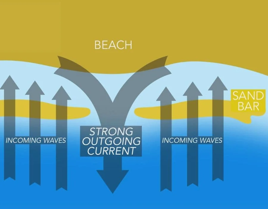
Rip Currents in Rivers: Description, Characteristics, and Influencing Factors
Rip currents are strong, localized currents that flow away from the shore, cutting through the incoming waves. While we typically associate them with coastal environments, rip currents can also occur in larger river systems.
They are usually caused by breaks in sandbars or obstructions that channel the water flow.
Concept of Laminar Flow and Turbulent Flow
Understanding the concepts of laminar and turbulent flow is critical in grasping river current dynamics.
Laminar flow, characterized by smooth, parallel layers of water, is typically found in slow-moving or still waters. Laminar flow primarily occurs in straight river sections. Remarkably, the speed difference between the top, middle, and bottom layers of the river becomes noticeable in such scenarios, with the topmost layer often moving the fastest due to less friction.
On the other hand, turbulent flow—characterized by chaotic, intermingling currents—is common in faster, rougher waters, like rapids. Turbulent flow arises due to factors like river width, depth, and obstructions. These conditions can lead to the formation of ‘riffles’—small waves that, under specific circumstances, can intensify and become choppy, adding another layer of complexity to river currents.
According to the US Geological Survey, these flows not only affect the behavior of river currents but also play a significant role in shaping river ecosystems and landscapes.
Formation and Identification of River Features
Rivers, with their diverse and ever-changing features, present both beauty and challenges to those who navigate them. Recognizing and understanding these features not only enhances the enjoyment of river activities but also ensures safety.
Navigating through rivers necessitates an understanding of various river features and how they impact the water flow.
Understanding Upstream “V” and Downstream “V”
When navigating rivers, understanding certain formations, particularly the Upstream “V” and Downstream “V”, is key. These formations are discernible patterns on the water’s surface that provide important information about the conditions underneath.
An Upstream “V” is a converging pattern that points in the direction of the current. This formation usually signifies deeper, safer waters, perfect for boating or fishing. Imagine you’re kayaking and see this pattern ahead; it would indicate a clear path where you can proceed without the risk of hitting submerged rocks.
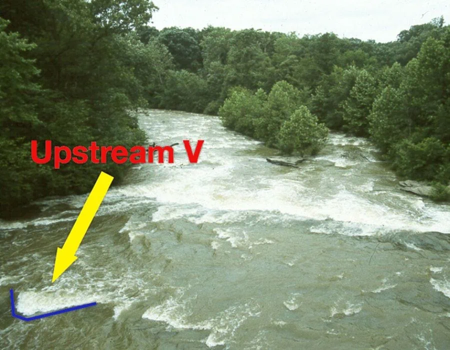
On the other hand, a Downstream “V” is a diverging pattern pointing against the current, indicating an obstruction like a rock or a shallow area. This formation can signify potential hazards. For instance, if you’re navigating a small motorboat and you spot a Downstream “V” in your path, it’s a sign that you should steer clear of that area to avoid damaging your boat or getting stuck.

These patterns, once understood, can significantly increase safety and efficiency in river navigation.
Eddies and Their Role in Safe River Operations
Eddies are calm areas in the water that form behind obstacles, providing a respite from the current. Understanding eddies is essential for river navigation, as they can be used as safe zones to rest, scout downstream conditions, or assist in rescue operations.
Strainers and Sweepers: Hazards to be Aware Of
Strainers and sweepers are obstructions in the river that allow water to pass through but block solid objects. They can pose significant risks to swimmers and boaters. For example, fallen trees can act as strainers, trapping and potentially capsizing boats.
Hydraulics or Holes: Dangers for Divers
Hydraulics, or holes, are formed when water flows over an obstacle and circulates back on itself. These can pose dangers, particularly for divers, due to their potential to trap individuals underwater. The American Canoe Association provides comprehensive safety guidelines for dealing with such situations.
Understanding River Right and River Left
In river navigation, “River Right” and “River Left” are essential terms used to indicate the sides of the river. As you face downstream, River Right is to your right, and River Left is to your left. These directional cues are vital for coordination during river activities like rafting, aiding in avoiding obstacles and ensuring safe navigation.

Exploring River Features: Riffles, Rapids, and Bends
Explanation of Riffles and Rapids
Riffles and rapids are dynamic rivers features that result from turbulent water flow over uneven riverbed surfaces.
Riffles are shallow, fast-flowing sections with small waves, created as water rushes over rocks or gravel. Rapids, on the other hand, are more intense and occur when the river gradient increases significantly, causing water to flow swiftly over obstructions, creating churning whitewater.
In essence, understanding the differences between riffles and rapids can greatly aid in navigation and safety, as navigating through riffles requires less technical skill compared to tackling rapids, which often demand specific whitewater navigation skills and equipment due to their turbulent and potentially dangerous nature.

Understanding How River Bends Affect the Direction and Speed of the Current
The curvature of a river bend greatly impacts the direction and speed of the current. On the outside of the bend, where the river channel is deepest, the water flows faster due to less friction.
Conversely, the water on the inside of the bend, where the river is shallower, flows slower. This discrepancy in speed creates a spiraling secondary flow, pushing surface water toward the outer bank and bottom water toward the inner bank.
Operational Measures for Safe Navigation Around These Features
Safe navigation around these features necessitates understanding their nature and potential hazards. For instance, capsizing is a risk in rapids, so wearing a life jacket and securing all gear is essential.
Knowledge of river bends helps predict current changes, allowing for adjustments to maintain course and speed.
Impact of River Currents on Ecosystems
River currents play a critical role in shaping the ecosystem surrounding them. They directly and indirectly affect various forms of life from aquatic creatures to terrestrial species, and even birds and insects.
Effect on Aquatic Life
Aquatic life, including fish, crustaceans, and aquatic plants, is significantly influenced by river currents. These currents distribute food and nutrients and offer a means of transportation for some species. For instance, salmon are known to navigate upstream against the current for spawning, a behavior critical to their lifecycle.
Influence on Riparian Zones
River currents also shape the riparian zones, areas adjacent to rivers and streams. These zones are biodiversity hotspots, with unique plant and animal species. The currents’ speed and volume determine the moisture level, aiding in the growth of specific plant species.

Impact on Bird and Insect Migration
Bird and insect migration patterns can also be affected by river currents. Some bird species use rivers as navigational guides during migration. Simultaneously, insects like mayflies and stoneflies have aquatic larval stages, making their life cycles dependent on the river’s flow.
For more in-depth information on the relationship between river currents and ecosystems, consider visiting the U.S. Geological Survey’s webpage on this topic.
Impact of Climate Change on River Currents
Climate change, primarily driven by human activities, is having profound impacts on river systems globally. It alters precipitation patterns, increases evaporation rates, and accelerates glacial melting, all of which can change river currents.
One significant effect of climate change is the alteration of river discharge patterns. Warmer temperatures lead to more rapid melting of snow and ice in watersheds, causing higher river discharge rates in spring and potentially leading to flooding. Conversely, during summer and fall, lower precipitation and higher evaporation rates can result in reduced river flows, leading to drought conditions.
The increased intensity and frequency of extreme weather events, another consequence of climate change, can also affect river currents. More frequent and severe storms can lead to higher runoff rates and potentially more intense river currents, increasing the risk of flooding and erosion.
Finally, rising sea levels can lead to increased backwater effects in lower river reaches, which can slow down river currents and exacerbate flooding during storm events.
In summary, climate change can significantly impact river currents, with profound implications for human societies and ecosystems that depend on these river systems. Understanding these impacts is crucial for developing effective strategies to adapt to and mitigate the effects of climate change on our rivers.
Measurement of river currents
River currents can be measured using various methods and instruments. One common method is to use a current meter, which is a device that measures the velocity and direction of water flow. Current meters can be deployed in the water and are equipped with propellers or impellers that rotate as water passes through them, providing data on the current speed.

Another approach is using a Doppler current profiler, which uses sound waves to measure the velocity of water particles. Additionally, modern technologies like Acoustic Doppler Current Profilers (ADCPs) and Remote Sensing technologies are employed to remotely measure and map river currents.
These methods help scientists and hydrologists gather valuable data on river currents, contributing to a better understanding of river dynamics and aiding in various applications such as water resource management and flood forecasting.
For all river enthusiasts – this is a great movie:
FAQs
What are the currents of a river?
The currents of a river refer to the continuous flow of water within the river channel, influenced by factors like gravity, topography, and weather patterns. They play a crucial role in shaping the river’s characteristics and impacting the surrounding environment.
What is a current in the water?
A current in the water refers to the movement of water in a specific direction, caused by various factors such as wind, tides, or the flow of a river. It can vary in speed and direction, affecting navigation, aquatic ecosystems, and recreational activities.
Are river currents strong?
River currents can vary in strength depending on factors like the slope of the river, volume of water, and presence of obstructions. Some currents can be strong, especially in rapids or areas with high flow rates, posing challenges for boaters and swimmers.
Where is the strongest current in a river?
The strongest current in a river is typically found in the center or deepest part of the channel, where the flow is typically faster due to less friction with the riverbed and banks. However, the strength and location of the strongest current can vary depending on the specific characteristics of each river.
Which river has the strongest current?
The Amazon River is often considered to have the strongest measured current among rivers worldwide. With its vast volume of water and immense width, the Amazon River exhibits a powerful flow that can reach impressive speeds, making it one of the most formidable rivers in terms of current strength.